| |
Celtic
Petroleum : Products : Basin Studies :
............................................................
Black
Sea Basin
Study
| Synopsis | Table
of Contents |
List of Plates |
Samples | Downloads |
Synopsis :
............................................................
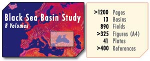
This
EIGHT VOLUME study covers an offshore and immediate onshore
area of 461,000 sq.km. compared to that of the North Sea.
Within a regional framework the study encompasses a much wider area
of 1,260,000
sq.km. - twice the area of Texas.
There are three volumes of ca. 1,200 pages of text and five
volumes of 41 maps and plates.
Volume one of text discusses the petroleum geology of the offshore
as well as an area of onshore from Eastern Bulgaria and Romania to
Thrace, Northern Anatolia, Western Caucasus, South-West Ukraine and
Bessarabia (now the Moldavian Republic).
Volumes 2 and 3 present an index of our 890 named oil and
gas fields, prospects, structures and individual wells.
The above three volumes contain over 325 illustrations in
text (A4 Format) and some 400 selected references, taken
from the English, French and Russian for the years 1960-1980,
1980 to 1990 and 1990 to present.
Volumes 4, 5, 6, 7 and 8 contain 41 large maps and montages
(4ft by 5ft). The maps are at working scales of 5 million, 2 million,
1 million, 500 thousand and 250 thousand, respectively.
The montages show correlations on stratigraphy, regional cross sections,
palaeogeography, plate tectonics etc.
The maps include isopachs, isobaths, total intensity magnetic field
and location maps of oil and gas fields, and structures.
This study is a cost-effective in-house working tool for future exploration
appraisal which should save you 90% of your preliminary costs as well
as offer you instant recognition of the hot exploration areas.
The Black Sea, including the Sea of Azov, covers an area of 178,000
sq. miles (514,420 km2) of which 52,725 sq. miles (152,376km2) is
continental shelf less than 200m. The majority of this shelf area
is incorporated in offshore Ukraine and Romania, with a lesser part
in offshore Bulgaria, Russia and Turkey.
At 52,725 sq. miles, the area of the Black Sea's continental shelf
(less than 200m) is approximately one-fifth the size of Texas (262,000
sq. miles) or the same size as Lousiana (52,000 sq. miles) or seven
times the size of Kuwait (7,680 sq. miles) and four times the size
of the Netherlands.
Given the important downstream infrastructure of the Black Sea (refineries,
pipelines, port facilities) combined with the rich potential, proven
reserves and the close geographic proximity to the Western markets,
we hope to interest you in acquiring the Studies.
Statistical Information :
............................................................
| Plates: |
|
| |
|
| Total
Seismics : |
1432.2
km
|
| Total
Geoseismics : |
3662.7
km
|
| Total: |
5094.9
km
|
| Number
of Structural Maps: |
16
|
| Number
of Seismic Horizons Mapped: |
10
|
| Scales: |
1:2M
/ 1:1M / 1:500K
|
| |
|
| |
|
| Text
(A3 & A4): |
|
| |
|
| Number
of Seismics/Geoseismic Sections: |
41 |
| Minimum
Length : |
>6000
km |
| Number
of Geological X-Sections : |
119 |
| Number
of Structural Maps : |
25 |
| Number
of Seismic Horizons Mapped : |
15 |
|